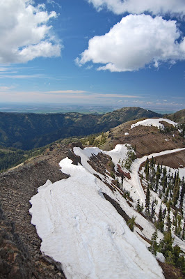
The Blue Mountains are a mountain range that covers the far Southeastern corner of Washington State and the far Northeast corner of Oregon. They are volcanic in nature; underlying the soil is a vast network of volcanic basalt shaped over the eons by water. The mountains are essentially a maze of ridgelines, rising from the valley at around 1000 feet elevation, to gentle peaks at up to 6500 feet elevation. The closest ski resort to Richland is Bluewood, nestled right in the middle of the range, completely isolated from civilization. Bluewood recieves 300 inches of snow per year.


It has been a cool and rainy spring here. In May and June so far, Richland has had about 3 times its normal rainfall, and has been about 5-10 degrees cooler than average since early April. My primary apprehension about deciding to hike there was that there might still be too much snow on the ground. We were planning on hiking the Slick Ear and the Grizzly Bear trails, that make an 18-mile loop through the mountains. Unfortunately, we found out that our fears were justified. We had to take a dirt forest service road to get to the trailhead, and we ran into thick, slushy snow at around the 5200 foot level, still miles from the trailhead. So we simply pulled off the trail, and began hiking right there along forest service roads. After two miles of hiking, we reached a signpost pointing to the "Tabletop Mountain Lookout" in 5 miles. So we made that our destination. At least half of this road between there and Tabletop was covered in snow, and towards the end, we had to scramble over steep rocks, so it was a very challenging 5 miles. The view was spectacular though. I'll let the pictures speak for themselves. From certain vantage points, we could see the valleys of Northeastern Oregon far below, and from others we could see across to the much more rugged Wallowa mountains, where we hope to hike later this month.


On the way back, I persuaded Aisling to take an adventurous detour down the spine of a snow-covered ridge. We had to cross a steep rushing creek to get back to the forest service road. Luckily, there was a snow-bridge across so we didn't have to wade in. The hike back up was a steep scramble over fallen logs and twisted brush. Aisling was not happy with me about that. The last few miles headed back to the car were quite challenging. We were doing the whole thing with around 30-40 pounds of gear on our backs to get used to the weight, and it really makes a difference. At the end of the day, my shoulders were really beat. My left knee also got tight, and I've vowed to stretch that out sufficiently so that it can handle some hardcore hiking at the end of the month.


I did indeed get grumpy (anticipating the steep climb to aggravate my hip and his knee), but you can't help but smile again when you return to the top and see that spectacular natural beauty without any other people in sight. The next day our joints felt good and our muscles felt lightly fatigued in a rewarding way. Wonderful hike- can't wait for our hiking adventure in 10 days! Look for our post at the end of June!
ReplyDelete